5th June 2013
After being on the road for a while now, and with so many sights to visit and experience so far, Sharon and I decided we'd take some time out at Mt. Isa and just do nothing for a day. We drove the short way into the heart of the CBD where we parked the Prado in one of the many sun-shaded spots in the street. We had a bit of a wander around but this is a bit of a strange place with many of the businesses closed up and for sale.
Thankfully, we did manage to find a "Coffee Club" outlet that seemed very popular so, after taking care of some banking, it was straight in for the usual Cappuccino and Long Black. This place has a full breakfast, lunch and dinner menu and was most impressive. It was a bit hard not to notice all the "Qld Maroons" State of Origin Rugby paraphernalia stuck up around the place so I brilliantly deduced a game must be on that evening.
I'd gotten really annoyed back at Alice Springs with the lack of T.V. reception we were experiencing and I'd spent a bit of time there mucking around with the leads and plugs and trying to get our antenna to do what it's supposed to do. When we're away in the 'van we don't usually watch much tele, but we do like to try and keep up with the News, so when I spotted a Bunnings store, we popped in a bought a better antenna.
So, once we got back to the Caravan Park, I got out some tools and set to work fitting the new acquisition. The couple from the 'van behind us wandered past and stopped for what ended up a fairly long chat. They were from N.S.W. and had been on the road for a while and started their trip in a pop-top 'van much like ours, but decided to upgrade to a 19' conventional 'van with an airconditioniner after the weather got unbearable the furter north in W.A. they went. There was also and older bloke that came over and started gas-bagging as soon as I lifted the bonnet on the Prado to top up the washer bottle. He proudly told me he had a Toyota too (a Land Cruiser) that had in excess of 300,000kms on the clock and was still going strong. He and his wife were getting around the country with a camper trailer in tow so it was a good opportunity to get his view on the practicalities of this type of touring.
Getting back to the tele antenna, I finally got it up and the t.v. happily tuned in to a bunch of digital stations. We were good to go.
The rest of the day was spent just sitting around and catching up on some blogging etc.
Later that evening, Sharon and I came to the realisation that we'd made a big mistake being in Mt. Isa during a State of Origin match. This town is rugby mad. There were groups everywhere watching the game and as the match rolled on, and the alcohol was consumed, so the noise level grew. We went to bed not knowing who'd won, but with the car horns blaring out on the street, and the hooting and hollering going on, we assumed it was Queensland. Someone in the street behind the Park was having a State of Origin party, which is apparently the thing to do, and the music blared at us 'til the small hours of the morning. Not a pleasant night.
We later discovered that N.S.W. beat Qld. quite convincingly so I'd hate to be around when they actually win!
Sorry, no photos today.
Farewell Northern Territory, hello Queensland
4th June 2013
Today we had a fairly long drive ahead of us with 675kms to Mt. Isa, so it was up early (for someone on holidays), a quick brekky and a slick pack-up job. We were underway before 8:00am and drove the half dozen kilometres north of Tennant Creek to the Shell roadhouse at Three Ways to top up the tanks. I was standing at the Prado's fuel filler door, bowser nozzle in hand waiting for the pump to come to life, and continued to wait, and waited some more thinking to myself...."This place didn't look that busy????" until I noticed a sign on top of the bowser that instructs you to leave Photo ID with the attendant before fuel will flow. Apparently "drive-offs" are a big problem up this way.
We eventually took care of the refuelling business and took off towards the Queensland border.
For several days now we'd been seeing masses of small termite hills on the roadside, usually no more that 40 to 50cm high. Now we began to see very different mounds, dotted throughout the bush, that were much, much larger and grandiose, and rounded. These were obviously built by the Grollo genis of termites.
The most remarkable thing here was seeing our first really big roadtrain, 4 trailers long. Until now there'd only been B triples, but this behemoth made them look like toys. It took the driver quite a distance to wind the whole rig up to speed after leaving the Roadhouse.


A short time before we rolled into Camoweal, we crossed the border into sunny Queensland. The temperature had climbed steadily over the day, and later peaked at 28 degrees. Sharon wanted to organise the payment of a bill, so when we pulled up at the public toilets in Camoweal, directly across the road from the Post Office, it was too good an opportunity. The Post Office was also the General Store so after Sharon took care of business, I selected a couple of Dixie Cup icecreans out of the freezer which went down well.
It was getting late in the afternon when we finally arrived at Mt. Isa and the first couple of Parks had no powered sites left. The Grey Nomads seem to have an annoying habit of travelling only short distances and setting up stumps shortly after lunchtime. This means that anyone puling in late had better hope they've booked ahead. Luckily we weren't too late and settled ourselves in for two nights at a smallish Park on the outskirts of town. Later that night I was over at the ammenities block taking care of some business when I heard and felt a massive, deep rumble that sounded like thunder. I know it hadn't come from me so I was wondering "Earthquake???" until I remebered Sharon reading out some interesting facts about Mt. Isa. This is a mining town, and the huge mine is down one end of town. At around 8:00am, and again at 8:00pm each day, the explosive charges that have been set by the preceeding shift are detonated. The noise and vibration of the blast can be felt across the whole town. Chalk up another unique experience.
Today we had a fairly long drive ahead of us with 675kms to Mt. Isa, so it was up early (for someone on holidays), a quick brekky and a slick pack-up job. We were underway before 8:00am and drove the half dozen kilometres north of Tennant Creek to the Shell roadhouse at Three Ways to top up the tanks. I was standing at the Prado's fuel filler door, bowser nozzle in hand waiting for the pump to come to life, and continued to wait, and waited some more thinking to myself...."This place didn't look that busy????" until I noticed a sign on top of the bowser that instructs you to leave Photo ID with the attendant before fuel will flow. Apparently "drive-offs" are a big problem up this way.
We eventually took care of the refuelling business and took off towards the Queensland border.
For several days now we'd been seeing masses of small termite hills on the roadside, usually no more that 40 to 50cm high. Now we began to see very different mounds, dotted throughout the bush, that were much, much larger and grandiose, and rounded. These were obviously built by the Grollo genis of termites.
 |
| Puny N.T. Termite mounds |
 |
| More stately Qld. mounds |
Another attempt at a cup of coffee was made at the Roadhouse at Barkly Homestead. This was another combination Roadhouse/Bar/Entertainment Venue that appeared to be the only thing around for miles. Unfortunately, their coffee vending machine had broken the day before so we paid our money and were given two paper coffee cups. They were improvising by plugging in a "Tiffany" electric jug where the dead machine had been removed from, and a container sitting nearby offered sachets of instant coffee or tea bags. To add insult to injury, the carton of milk provided was UHT!
The most remarkable thing here was seeing our first really big roadtrain, 4 trailers long. Until now there'd only been B triples, but this behemoth made them look like toys. It took the driver quite a distance to wind the whole rig up to speed after leaving the Roadhouse.

After all the magnificent scenery we'd witnessed, and the ever-changing hills, mesas and ranges, we drove over a rise to be faced with a wide expanse of ....nothing. There was literally no feature, tree or animal to be seen for as far as could be seen.

Little wonder there's nothing and no-one out there, and there's no fuel for the 260kms between Barkly Homestead and Camoweal so you'd better hope for favourable winds. The wind that day was not favourable to us and we drove most of the day with a fairly stiff breeze coming from the passenger side and slightly head-on. Our fuel consumption figure rocketted to 17.2 litres per 100kms, but with 150 litres of diesel on board, we had plenty of range to spare.
A short time before we rolled into Camoweal, we crossed the border into sunny Queensland. The temperature had climbed steadily over the day, and later peaked at 28 degrees. Sharon wanted to organise the payment of a bill, so when we pulled up at the public toilets in Camoweal, directly across the road from the Post Office, it was too good an opportunity. The Post Office was also the General Store so after Sharon took care of business, I selected a couple of Dixie Cup icecreans out of the freezer which went down well.
It was getting late in the afternon when we finally arrived at Mt. Isa and the first couple of Parks had no powered sites left. The Grey Nomads seem to have an annoying habit of travelling only short distances and setting up stumps shortly after lunchtime. This means that anyone puling in late had better hope they've booked ahead. Luckily we weren't too late and settled ourselves in for two nights at a smallish Park on the outskirts of town. Later that night I was over at the ammenities block taking care of some business when I heard and felt a massive, deep rumble that sounded like thunder. I know it hadn't come from me so I was wondering "Earthquake???" until I remebered Sharon reading out some interesting facts about Mt. Isa. This is a mining town, and the huge mine is down one end of town. At around 8:00am, and again at 8:00pm each day, the explosive charges that have been set by the preceeding shift are detonated. The noise and vibration of the blast can be felt across the whole town. Chalk up another unique experience.
 |
| Mt. Isa mine |
Finally, we've seen a live kangaroo!
3rd June 2013
We left Alice Springs this morning and continued north with the aim of stopping in Tennant Creek that night.
A little way down the road we saw our first kangaroo since before Coober Pedy. We'd been commenting on how there didn't seem to be any around Uluru, Kings Canyon and Alice, and how if you were an overseas tourist you'd probably be dissappointed.
After a long period of not-much-to-remark-about, we came upon the Devil's Marbles. These are curious clusters of mostly rounded boulders out in the middle of nowhere, some stacked on top of each other to form piles.


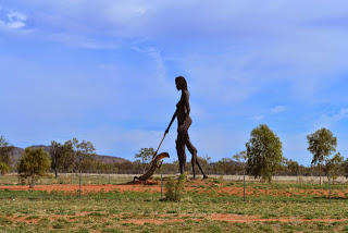
The time to stop for a coffee break coincided with our arrival at another strange place called Aileron, essentially a very small community centred around the roadhouse/pub. This place's stand-out feature is the huge metal sculpture of an Aboriginal warrior, seen as you approach the town, and another of a woman and child as you leave.

We left Alice Springs this morning and continued north with the aim of stopping in Tennant Creek that night.
A little way down the road we saw our first kangaroo since before Coober Pedy. We'd been commenting on how there didn't seem to be any around Uluru, Kings Canyon and Alice, and how if you were an overseas tourist you'd probably be dissappointed.
Our progress once again came to a halt to allow some cattle to leisurely make their way off the highway.
 |
| Pedestrian crossing, outback style. |


The time to stop for a coffee break coincided with our arrival at another strange place called Aileron, essentially a very small community centred around the roadhouse/pub. This place's stand-out feature is the huge metal sculpture of an Aboriginal warrior, seen as you approach the town, and another of a woman and child as you leave.


 |
| A quirky "couple" seen outside the Aileron Roadhouse |
We strolled into the Roadhouse and the young fella asked what we'd like. Sharon ordered "A Cappucino and a Long Black to have here please." to which he replied "Come into the Bar area". We stepped half a dozen paces to the left, and were in The Bar, where the young bloke, now the Bar tender, handed us two cups and pointed to the coffee vending machine standing on a table behind us. Not the best cup of coffee either of us have ever had, but an amusing experience anyway.
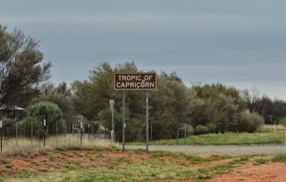
The rest of the drive to Tennant Creek gave us nothing more worth noting apart from the fact that we did cross the Tropic of Capricorn.

Another helping of Chasms, Gaps and Gorges
2nd June 2013
Today we planned to explore more of the West MacDonnell Ranges, taking in Redbank, Glen Helen and Ormiston Gorges, a look at the Ochre Pits and finally, Ellery Creek Big Hole.
These locations were the futhest we've had to drive from Alice and we turned off the Larrapinta Highway towards Glen Helen. Ever since hitting outback S.A. there'd been warnings about cattle and livestock on the roads due to the lack of fences so we'd become accustomed to spotting all sorts of creatures on and near the road. Up 'til now, whatever the beast was, it'd make it's way off the road, usually in a fair degree of fright, but occasionally, in it's own good time. Not today. We came round a bend and two horses were feeding on the grass at the roadside, with one plonked fair across the road. A car coming the other way came to a dead stop, as did we. The woman then drove slowly around the horse blocking her path. Neither horse even looked up or showed any concern and continued to go about their business. We drove slowly past them too, also without soliciting any reaction from the horses.


First stop for the day was at Redbank Gorge, the drive in was a little rough, but there were a few conventional cars making it in without trouble.


There's also has an area for caravans which looked little more than a dirt carpark but had it's fair share of campers just the same.


Today we planned to explore more of the West MacDonnell Ranges, taking in Redbank, Glen Helen and Ormiston Gorges, a look at the Ochre Pits and finally, Ellery Creek Big Hole.
These locations were the futhest we've had to drive from Alice and we turned off the Larrapinta Highway towards Glen Helen. Ever since hitting outback S.A. there'd been warnings about cattle and livestock on the roads due to the lack of fences so we'd become accustomed to spotting all sorts of creatures on and near the road. Up 'til now, whatever the beast was, it'd make it's way off the road, usually in a fair degree of fright, but occasionally, in it's own good time. Not today. We came round a bend and two horses were feeding on the grass at the roadside, with one plonked fair across the road. A car coming the other way came to a dead stop, as did we. The woman then drove slowly around the horse blocking her path. Neither horse even looked up or showed any concern and continued to go about their business. We drove slowly past them too, also without soliciting any reaction from the horses.

More kilometres of driving, with the passing scenery forever changing, as did the appearance of the distant ranges, some of which were capped in cloud.


First stop for the day was at Redbank Gorge, the drive in was a little rough, but there were a few conventional cars making it in without trouble.

The walk to the gorge itself was, at times, very hard going, forcing us to sometimes rock-hop over and around small to large rocks littering the river floor. But the end goal was worth the effort. The gorge turned out to be a narrow, zig-zag shaped gap between two rock walls.
 |
| One of the many unusual rocks we had to negotiate |
 |
| Redbank Gorge |
We'd driven past the Glen Helen Resort to get to Redbank, so we backtracked to the resort, parked the car and walked the short, easy distance to the gorge. The resort is located on the edge of yet another creek, featuring a permanent waterhole suitable for swimming. The entrance to the gorge itself is full of water and you have to climb out over rock shelves to get a clear view into the gorge.

There's also has an area for caravans which looked little more than a dirt carpark but had it's fair share of campers just the same.

Next on the agenda was Ormiston Gorge. This area too has a campround suitable for caravans and motorhomes, and there were quite a few sites already taken. Next to the carpark we were surprised to find a Kiosk. Very handy for the campers. Ormiston Gorge is another that has permanent water and is suitable for swimming, it even has a life preserver hanging on a post in case of emergencies. There's evidence of huge volumes of water passing through the gorge at some time that has caused huge slabs of the rock face to drop where it's been undercut.


By this time we're now steadily making our way back eastwards towards Alice and the next detour was to the Aboriginal Ochre Pits. The information board here tells that the local tribes have been collecting ochre, mostly the yellow, from this site for a couple of thousand years. Ochre was used in some form by the Aborigines in everyday life. Apparently it was used to decorate and protect weapons and as body paint for ceremonies, it was also a key ingredient in various medicine and was a valuable commodity when trading with other tribes. The ochre was originally formed in horizontal layers, but a violent upheaval pushed them upwards almost pependicular, leaving the vertical stripes we see today. The colours are amazing, ranging from gold to crimson.

Ellery Creek Bighole, once again, is a gorge filled with a permanent water pool. A very popular campground sits at the entrance to this gorge and is a very short walk to the sandy beach lining the waterhole. There appeared to be a number of families camped here who were enjoying activities around and on the water.
 |
| Ellery Creek Big Hole |
Simpson's Gap, Standley Chasm and the Old Alice Springs Telegraph Station
1st June 2013
Today we drove out west of Alice to visit one of the most well known of the sights in this area, Standley Chasm. But first port of call was Simpson's Gap.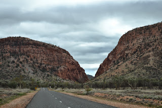 The Gap was a welcome change from the other Gaps and Chasms in that it has a semi-permanent pool of water.

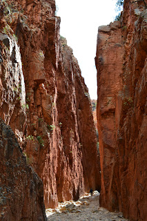 After Simpson's, we hopped over to Standley Chasm. We gathered that this location must be run privately as it was the first place, other than Uluru/Kata Tjuta, where we'd had to pay entry fees. Anyway, we paid our money and made the trek into the Chasm. Unfortunately the day was pretty grey and overcast so the walls didn't light up as brightly as it reportedly does at around midday when the sun is directly overhead. Regardless, a few breaks in the cloud did see some rays making it through and showing us a hint of the vibrant colour in the rock.
Today we drove out west of Alice to visit one of the most well known of the sights in this area, Standley Chasm. But first port of call was Simpson's Gap.
 The Gap was a welcome change from the other Gaps and Chasms in that it has a semi-permanent pool of water.
 After Simpson's, we hopped over to Standley Chasm. We gathered that this location must be run privately as it was the first place, other than Uluru/Kata Tjuta, where we'd had to pay entry fees. Anyway, we paid our money and made the trek into the Chasm. Unfortunately the day was pretty grey and overcast so the walls didn't light up as brightly as it reportedly does at around midday when the sun is directly overhead. Regardless, a few breaks in the cloud did see some rays making it through and showing us a hint of the vibrant colour in the rock.
Back in Alice and out the north end a few kilometres is the old Telegraph Station, reportedly the most complete and best preserved of all the stations that were constructed every 250kms along the telegraph line between Darwin and Adelaide. This was Australia's only link to the outside world and the station at Alice was one of the most important and was the birthplace of the town that became Alice Springs.

Chasms, Gaps and Gorges, some 4wd'ing and the deepest water crossing we've made yet
31st May 2013
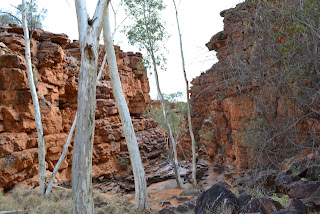
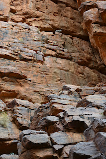
Today we toured the East MacDonnell ranges, located oddly enough, to the east of Alice Springs. The first stop was at Emily Gap, just 10kms out of town.

The Gap is a cleft carved into the rock by the flow of water and the walk between the walls is over a dry creek bed. This location holds important significance to the local Eastern Arrernte Aboriginal People, with a gallery of rock paintings depicting three Caterpillars from their Dreamtime stories.
Next, it was on to Jessie Gap a little ways down the road, which was similar to the previous, but much wider. Here too there were paintings of the Caterpllars, but also an explanation of the off-whitish colouring we've noticed on the surface of some of the rock. According to Aboriginal stories, this is the result of Emu fat left on the rock.
Again, a short distance further on was Corroboree Rock, a large dolomite rock standing alone and away from the base of the ranges. It's believed that no actual corroborees were held there due to the lack of water, but it still holds importance to the Arrernte people.
Our next stop was to be Trephina Gorge, but a short way into the Reserve, there's a fork in the road with one direction heading off to Trephina, whilst the other was a 4km, high-clearance 4wd vehicle only track to the John Hayes Rockhole. Sounded like a challenge too good to pass up so we hooked left and drove towards he rockholes. The track was narrow and a bit rough at times, even rougher at other times, but always picturesque and enjoyable with a number of crossings of the dry, sandy creek bed. There was a section of rock-hopping at the end which we took carefully and slowly, but without any hassles or concerns. The Prado handled it all beautifully. In the carpark at the end we chatted to a couple who were just leaving who'd spotted a rock wallaby perched high up on the wall of the chasm overlooking the rockhole.

We made our way back to the fork in the road then on to Trephina Gorge, which has well laid out campgrounds and odour-free self-composting toilets. A location to consider staying next time we're back this way. The Gorge itself is very wide and is seen by walking a couple of hundred metres along another sandy, dry creek bed lined with rugged , red walls.

 Before we drove out of the Reserve we took a short detour to observe a lone ghost gum standing a short distance apart from the others. This specimen is most impressive, and the info panel says it's believed to be more than 300 years old.
Back on to the main road and on to take a look at the Rich River Resort (I reckon calling it a "resort" is a bit "rich"). It's not exactly what you'd be accustomed to if you've seen any of the Qld. island resorts. This place looks a bit like an old school camp, but it does have a helicopter and pilot who can take you on scenic flights over the ranges. Even the chopper looks old and is one of the old "bubble" cockpit Bell 47 models as seen on M.A.S.H. We didn't waste too much time here and just drove straight in and straight out again.
A few hundred metres later we left the main road to join a section of "Binns Track". This is actually a 2191km route starting at Mt Dare S.A. and ending at Timber Creek N.T. and is promoted as a selfdrive 4wd adventure route. The small segment we drove was about 80kms long and started off with a creek crossing. The only problem was, our way was blocked by a Ssangyong 4wd (???) ute that had stopped mid stream and wasn't going anywhere without help.
 The old bloke driving it was out and standing round the front of the vehicle in water just above his knees. Fortunately, there was another vehicle (a red Holden ute) that had tried the same crossing just ahead of him and gotten his camper trailer bogged. He'd already unhitched the trailer, driven onto solid ground, attached his tow strap and dragged his trailer to high ground and was going back to help the still stranded ute. Sharon's theory is that the Holden and camper trailer churned up the bottom ahead of the bloke in the Ssangyong and it dropped down into the hole they created. Anyway, the first bloke with the trailer snatch recovered the Ssanyong which wasn't actually bogged but had either inhaled water, or the ignition had gotten wet.
As soon as the crossing was cleared, along came a big, jacked-up Landcruiser approaching from the other side who confidently hit the water, drove straight through and up the other side with no dramas. The couple hopped out to chat and see if they could lend any assistance. Sharon and I talked to the wife who advised us that we needed to go as far over to the left of the crossing as possible as this was the shallowest path and that the track was spectacular and a lot of fun.
So, now our way was clear and we took to the water with more than a little anxiety. But the water was crystal clear and we could easily see the bottom, so it was in, across and out again with the water probably not much deeper that the side steps. The Prado performed as expected and we were back on our way again.


Today we toured the East MacDonnell ranges, located oddly enough, to the east of Alice Springs. The first stop was at Emily Gap, just 10kms out of town.

The Gap is a cleft carved into the rock by the flow of water and the walk between the walls is over a dry creek bed. This location holds important significance to the local Eastern Arrernte Aboriginal People, with a gallery of rock paintings depicting three Caterpillars from their Dreamtime stories.
 |
| Aboriginal Rock Paintings of the three Caterpillars |
Again, a short distance further on was Corroboree Rock, a large dolomite rock standing alone and away from the base of the ranges. It's believed that no actual corroborees were held there due to the lack of water, but it still holds importance to the Arrernte people.
 |
| Corroboree Rock |


We made our way back to the fork in the road then on to Trephina Gorge, which has well laid out campgrounds and odour-free self-composting toilets. A location to consider staying next time we're back this way. The Gorge itself is very wide and is seen by walking a couple of hundred metres along another sandy, dry creek bed lined with rugged , red walls.

On the inside of the bend there are some ghost gums that have picked the most precarious place to grow.
 Before we drove out of the Reserve we took a short detour to observe a lone ghost gum standing a short distance apart from the others. This specimen is most impressive, and the info panel says it's believed to be more than 300 years old.
 |
| Ghost Gum more than 300 years old |
Back on to the main road and on to take a look at the Rich River Resort (I reckon calling it a "resort" is a bit "rich"). It's not exactly what you'd be accustomed to if you've seen any of the Qld. island resorts. This place looks a bit like an old school camp, but it does have a helicopter and pilot who can take you on scenic flights over the ranges. Even the chopper looks old and is one of the old "bubble" cockpit Bell 47 models as seen on M.A.S.H. We didn't waste too much time here and just drove straight in and straight out again.
A few hundred metres later we left the main road to join a section of "Binns Track". This is actually a 2191km route starting at Mt Dare S.A. and ending at Timber Creek N.T. and is promoted as a selfdrive 4wd adventure route. The small segment we drove was about 80kms long and started off with a creek crossing. The only problem was, our way was blocked by a Ssangyong 4wd (???) ute that had stopped mid stream and wasn't going anywhere without help.

As soon as the crossing was cleared, along came a big, jacked-up Landcruiser approaching from the other side who confidently hit the water, drove straight through and up the other side with no dramas. The couple hopped out to chat and see if they could lend any assistance. Sharon and I talked to the wife who advised us that we needed to go as far over to the left of the crossing as possible as this was the shallowest path and that the track was spectacular and a lot of fun.
So, now our way was clear and we took to the water with more than a little anxiety. But the water was crystal clear and we could easily see the bottom, so it was in, across and out again with the water probably not much deeper that the side steps. The Prado performed as expected and we were back on our way again.
Even the small section of Binns we drove offers a bit of everything. One minute we were knee-deep in water, next bouncing over rough rocky patches, then through soft dusty bowls, across numerous dry sandy creek beds, and even some obstacle avoidance when roaming cattle and horses wander into your path. We had a great time experiencing a small sample of this route and the scenery only added to the enjoyment. It certainly has whetted our appetite to try some of the more famous 4wd tracks like the Oodnadatta and Tanami.


The sun was getting pretty low on the horizon when we finally made it back onto the bitumen and we got back to the van tired, but well pleased with the day's event.
Hello Alice!
30th May 2013
 This morning we woke to a spectacular sun rising over the Canyon, made even more impressive by some scattered high cloud.
Today we decided we'd treat ourselves to breakfast at the Roadhouse/Cafe near the entrance to the Campgrounds. They have the usual menu as well as the option of a full buffet breakfast. Sharon and I both decided on the bacon and scrambled eggs, which also entitles you to help yourselves to the juices and coffee.
After an enjoyable brekky, we wandered back to the van to finish packing up, then it was back out to the Lassiter Highway and then the Stuart.
We'd been seeing evidence of Camels on the roads prior to Uluru and this morning we finally spotted a group grazing in the bush close to the roadside.

After a quick stop for fuel and a bite of lunch at the Erldunda Roadhouse we were on our way again and making a bee-line for Alice Springs.
 |
| Road Trains at Erldunda, lunchtime |
The rest of the drive was pretty much uneventful with the terrain still changing every half dozen kilometres but now with some large rocky outcrops thrown into the mix.
We arrived in Alice and went directly to the MacDonnell Range Holiday Park, booked for 3 nights, and settled ourselves onto our site.
Our first quest was to find a Tourist Information office which proved a lot more difficult even with the blue "i" signs pointing the way. They're not that big on direction and advisory signage up here and it took us a few blockies to find what we were loking for. Eventually, we spotted our target, parked the car, and entered the air conditioned comfort of the Visitors Centre. Sharon spent some time gathering info on the drives and destinations we intended to visit over the next 3 days and we left fully armed. Next stop was a short drive to the back of town and a steep climb to the lookout atop ANZAC Hill. From here you can get a full 360 degree view of Alice Springs in all its glory.

 Once we'd taken our fill of photos and video, the next exercise was to find a supermarket. These seem to all be located in the busy heart of the CBD and by the time we'd bought what we needed and run the gauntlet exiting the carpark, almost getting wiped out by a carelessly reversing motorhome in the process, we thought we were just about over Alice Springs.
We'll see what tomorrow brings.

Subscribe to:
Posts (Atom)