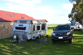
Rapid Bay, Myponga, Hindmarsh Valley, Deep Creek Conservation Park. 9th Oct 2012
After a comfortable night's rest, we woke to a bright and cloudless day.
Di and Dave hopped into the car with us and and guided us to a few locations they'd visited over the previous couple of days.
 |
| Old unused jetty behind the new. |
The first stop was a little down the road at Rapid Bay, which has a large, open campgroud, no power or showers, an uninterupted view of the beach, and handy to the old derelict jetty which is popular with divers hoping to catch a sighting of the elusive leafy sea dragon.
Another short hop to the HMAS Hobart Memorial overlooking Lady Bay. The Hobart was a Destroyer that served Australia for 35 years before being de-commissioned and subsequently scuttled in 2002, now providing a habitat for local marine life. The ship's anchor has been situated at the memorial such that it points to the ship's final resting place.
 |
| The view back towards Rapid Bay. |
 |
| Looking North to Yankalilla Bay |
A bit more driving and it was time for a coffee break so we hit the local Bakery at Myponga. Back in the car and after a few wrong directions coming from the back seat (Dave had the map) we continued to follow the Tourist Trail and stopped off to take a couple of short walks to some waterfalls.
The Trail brought us out on the edge of the Deep Creek Conservation Reserve, and a chance for us to test out the new Prado on some dirt road. After a few K's we pulled up at a diversion off the main track that we had to purchase a pass to use and was open to 4wd vehicles only. We all agreed that it might be interesting to take a look so Dave filled out the paperwork and paid the fee and we were in. Not far down the track we came upon a couple of Parks Officers busy with a chainsaw clearing a reasonable sized tree that had fallen across the track. It turns out they'd only opened the trail 5 minutes earlier after being closed for the Winter., but assured us the way was clear from there on. So, we pushed on and found ourselves looking out over a spectacular landscape towards a brilliant blue sea and spotless sky. The "road" at this point was almost two lanes wide, dry, lightly gravelled but to our inexperienced eyes, quite steep with a number of switchbacks. Being a novice offroader, I turned on the Descent Assist Control (DAC), took my feet away from the break and accelerator, and let the "smarts" do all the work. It was a reasonably slow trip down the hillside, but the DAC did such a great job, I don't think the tyres broke traction once.
 |
| Road to Boat Harbor Beach |
Funny, but it didn't look so steep going back up and we made it back onto the main Tourist Trail again and back "home" in no time.
We dropped Di and Dave back at the 'vans then Sharon and I drove the last couple of kilometers to the end of the Cape to watch the Kangaroo Island ferry load up and cast off. The weather had started to turn by this time with the wind gusting up a bit and showers passing over, but the stretch of water between the mainland and the island was surprisingly calm. The crew were very efficient at cramming as many vehicles as possible onto the deck.
When we got back to the 'van we were surprised to see how many caravans, motorhomes and campers had moved in whilst we were away. Being the closest camping area to the Kangaroo Island ferry it seems that most people stop here overnight ready to jump aboard the ferry next day.
Anyway, despite there being quite a few campers, the place was still quiet and peaceful and a great place to kick back for a while.


